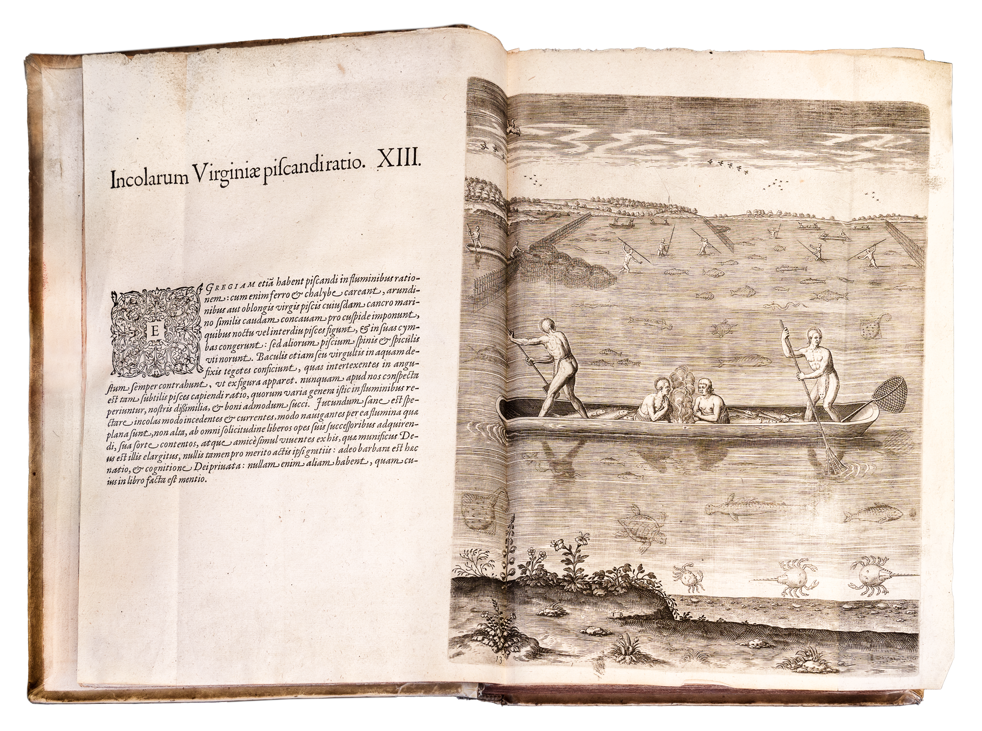
PART 1 (1590) The English attempt at settlement in Virginia
(Contained in Volume 1 and have another individually bound copy.)
- First engraved map of Virginia - was the basis for most European maps for eighty years.
- 28 copperplate engravings.
- The engravings were based on water colour paintings by John White who was the artist on Raleigh’s ill-fated Roanoke Colony - an early attempt to claim Virginia forth English. (1585-86).
- The text “Brief and true report of the new found land of Virginia.” is by Thomas Harriot (English astronomer, mathematician, ethnographer and translator) whom Raleigh designated as the group’s scientific advisor.
- Engravings of native American ( Algonquian) customs, artifacts, rituals, fishing and dwellings.
PART 2 (1591) The French attempt at settlement in Northern Florida.
(Contained in Volume 1 only )
- 42 Engravings based on Jacques le Moyne de Gourges water colours. Le Moyne was the appointed artist on the expedition which sailed in 1564.
- Engravings of the local Timuca people - daily life, ceremonies and hunting.
- An account of the French in Florida under Laudonniere, (French explorer) Ribault, ( French naval officer) and Gourges.
- Huguenot (French Protestants supporting the Reformation) Colony 1562-1565.
- Most elaborate map of Florida to appear in the 16th century. (Coastline charted by Le Moyne)
PART 3 (1592) Hans Staden’s ( German adventurer) captivity by cannibals in Brazil (1547-55)
(Contained In Volume 1 and have second individually bound copy.)
- John Lerio’s voyage and description of Brazil.
- Account of manners, customs and artefacts of the local Tupinamba people.
- 45 plates and map of South America, one of the most accurate of its time.
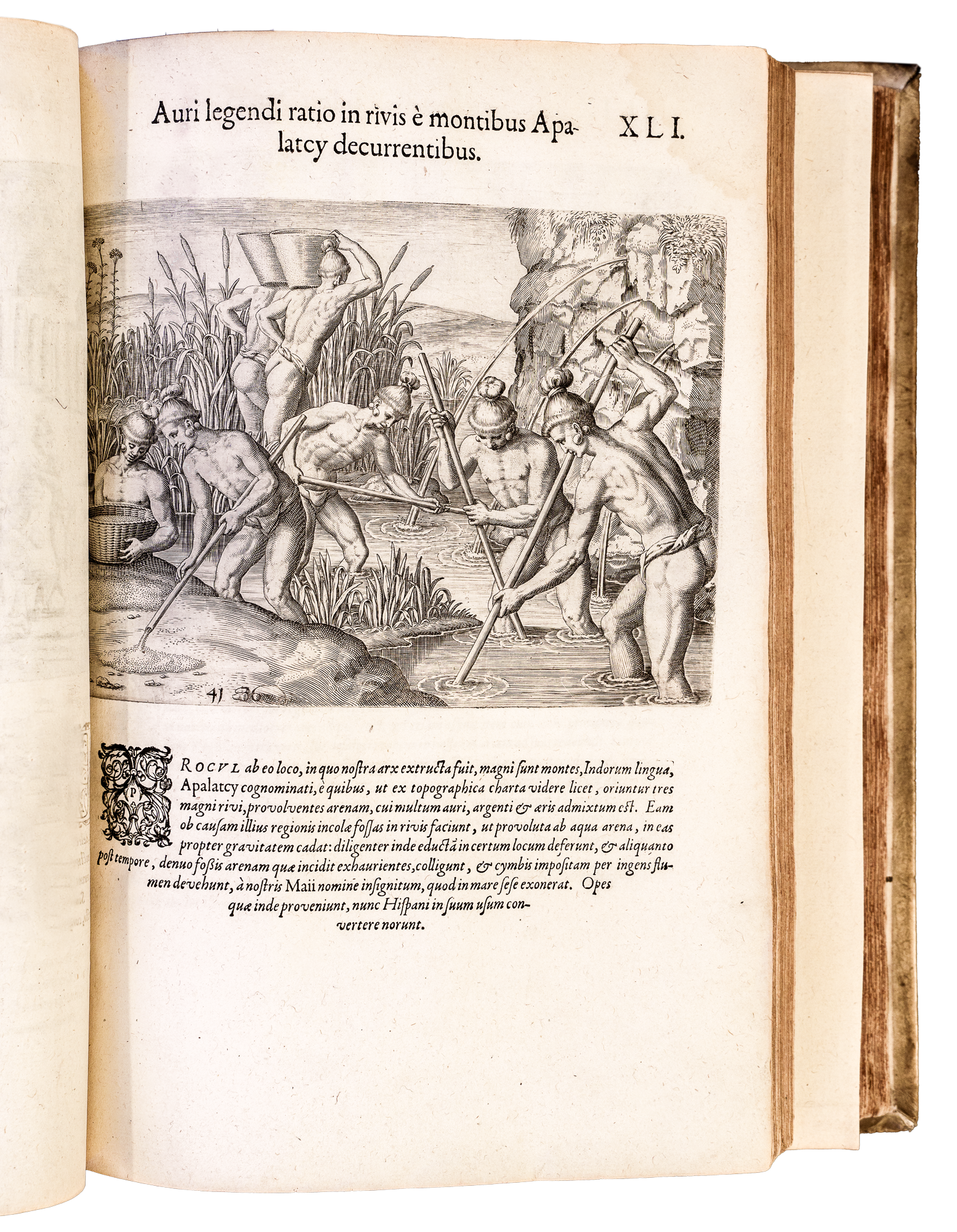
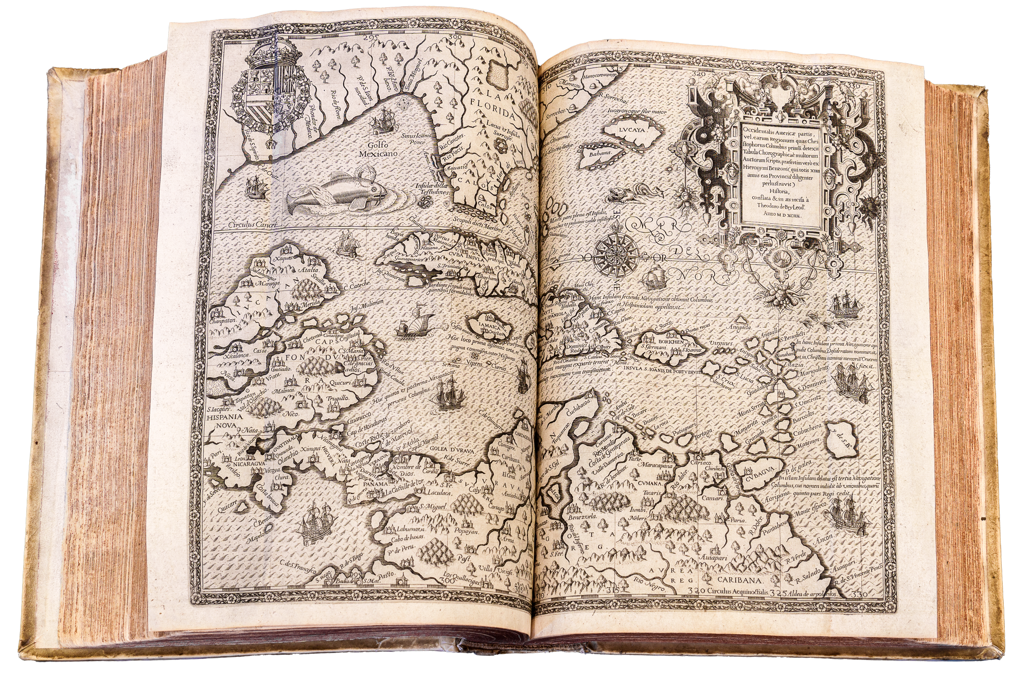
PARTS 4-6 ( 1594-1596) Girolamo Benzoni’s (Italian Conquistador and Merchant) account of the Spanish in Central America. Benzoni’s 15 years of travels in Spanish territories of Central and South America - based on his experiences and observations. Based on “Benzoni’s History and description of the New World” Translation of his first book.
- Part 4 (1594) Double page engraved map of West Indies. 24 engravings.
- Voyages of Columbus.
(Contained In volume 1 and have second individual copy )
- Part 5 (1595) Double page map of New Spain (Spanish colony north of isthmus of Panama).
( Contained In volume 1 and have second individual copy.)
- Translation of Benzoni’s second book including the petition on behalf of families of those massacred there by the Spanish in 1565 - repeated from America part 2.
- Part 6 (1596) Double page engraving of city of Cusco, Peru, once the capital of Inca Empire.
(Contained only in volume 1.)
- Description of Canary Islands.
- Double page map of Western Hemisphere with portraits of Columbus, Vespucci, Magellan and Pizzaro at its corners.
PART 7 (1599) / 2nd edition 1625 Description of the West Indies by Ulrich Schmidel
( Contained in volume 2 and have copy of 2nd edition 1625)
- Important early accounts of Latin America.
- Voyages of Ulrich Schmidel ( German explorer ) to Brazil and Paraguay.
- The Rio de la Plata ( The River Plate) -early exploration.
PART 8 (1599)/ 2nd edition 1625 Sir Walter Raleigh’s expedition to Guiana in search of El Dorado.
(Contained in volume 2 and have a copy individually bound 2nd edition.)
- Raleigh led an expedition to Venezuela in 1595 and set off in vain to search for El Dorado, the fabled city of gold in the South American interior.
- Double page engraved map of Guiana.
- Voyages of Sir Francis Drake (English sea captain and explorer) and Sir Thomas Cavendish (English explorer and privateer) log books. Their voyages demonstrated English maritime intent by circumnavigating the globe in 1570s and 1580s, destroying Spanish fleets and fortresses.
- Titlepage has a double hemisphere world map - including Terra Australis.
- 2nd edition - The expedition by the Dutch in1599 led by Pieter van der Does.
- The Voyage of Van Noort.
PART 9 ( 1602 ) / 2nd edition 1633 Father Joseph de Acosta’s natural and moral history of the West Indies.
(Contained in volume 2 and have 2nd edition individually bound.)
- Acosta, a Spanish Jesuit priest left Spain in 1570 for the New World - his book is an exposition of 16th century ideas on Physical Geography.
- A look at the ancient civilisations of Peru and Mexico. Local inhabitants working mines, llamas as beasts of burden, Aztec religious rites, human sacrifice and funerals.
- Dutch voyages of Olivier van Noort round the world 1600 and Sebard de Weert to the straits of Magellan 1598. Maps of Magellan Straits, Map of Borneo.
PART 10 (1619) Letters of Amerigo Vespucci. (Italian explorer, cartographer, navigator) - account of his two voyages 1497 and 1499.
(Individually bound volume.)
- Double page map of China, Borneo, Java.
- Story of Pocahontas ( daughter of the Great Powhatan) marriage to John Rolfe written by Ralph Hammer ( one of the original colonists to settle in Virginia). John Rolfe, an English settler- credited with the first successful cultivation of tobacco as an export crop in Virginia.
- Capt. John Smith’s 9 English soldier, explorer and colonial governor) description of New England.
- An account of Virginia.
PART 11 (1619) /appendix 1620 Voyages of Willem Corneliszoon Schouten ( Dutch navigator for the Dutch East India Company) and Jacob Le Maire (navigator who circumnavigated the world 1615-1616) round Cape Horn.
(Individually bound copy and an individual appendix)
- The first two Dutch circumnavigations.
- Titlepage double hemisphere map with portraits of Magellan and Schouten.
- Maps of Straits of Magellan and Le Maire Strait.
- Appendix (1620) Joris van Speilbergen’s (Dutch naval officer) voyage round the world 1615-1616.
- with the Australian Navigations discovered by Jacob Le Maire.
- Maps of New Guinea, South Pacific, Straits of Magellan and Le Maire Strait.
PART 12 ( 1624) Antonio de Herrera y Tordesillas ( Spanish historian)- description of the West Indies and Mexico.
(Individually bound copy)
- A collection of important voyages to the West Indies and around South America.
PART 13 ( 1634) Voyages of Pedro Fernandez de Quiros (Portuguese navigator in the service of Spain ) and Luis Vaez de Torres. (Spanish maritime explorer)
- Voyage of the Nassau fleet under Jacques le Hermite (Dutch merchant and explorer).
( Individually bound copy)
- Description of New England, Virginia, Somer Islands, Brazil and Guiana. The English in Guiana.
- Dutch expedition to Brazil under Admiral Lock 1628-29.
- Double page map of Brazil.
- In 1660 de Quiros and de Torres led two Spanish ships from Peru in the hope of locating the Great South Land - they reached an island of the New Hebrides group, Espirito Santo - they mistakenly thought they had reached their destination. Quiros returned to Peru. Torres continued along the South Coast of New Guinea through the strait that now bears his name and sighted Mainland Australia.