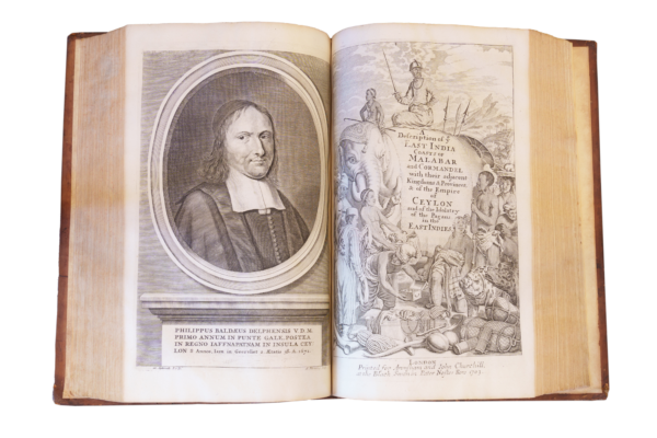
Treasures
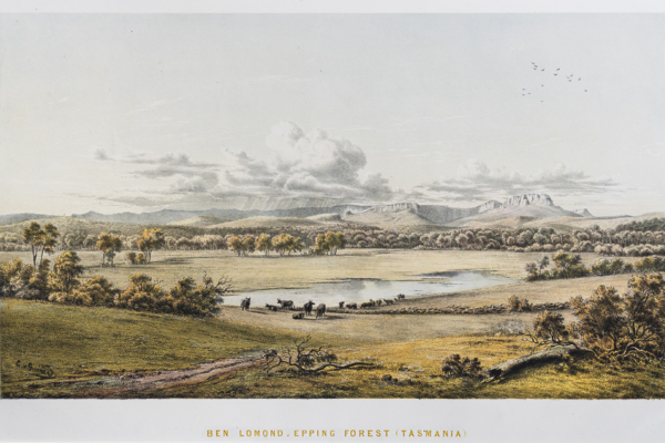
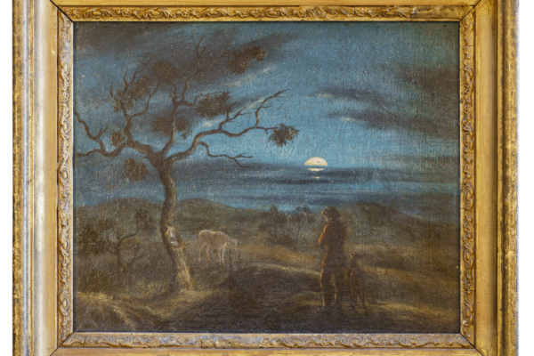
Von Guerard, Eugene - Australian Landscapes (1866-1868)
Eugene von Guerard (1811-1901) was an Austrian artist who came to the goldfields of Victoria in 1852. Settling in Melbourne he travelled extensively and became known as Victoria’s greatest 19th century landscape painter. Between 1866-1868 he published twenty-four coloured lithographs of landscapes of Victoria, South Australia and New South Wales and Tasmania of which the RGSSA holds a number.
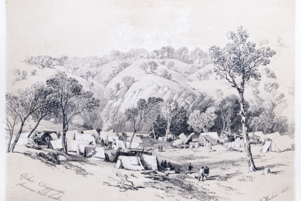
George French Angas - Views of the Gold Regions of Australia, 1851
Views of the Gold Regions of Australia, Drawn on the Spot by G.F. Angus [Angas], 1851 [1852] London: J. Hogarth.
This is the rare London edition of George French Angas’s folio set of six uncoloured lithographs depicting the gold-rush to Ophir, near Bathurst, in May 1851. Angas walked there from Sydney, ‘crossing the Blue Mountains on foot, and sleeping under a dray at nights, in the depth of winter’.
Tench, Watkin - Two books about the colony of NSW in 1789 and 1793
Watkin Tench served in the Royal Marines in the Royal Navy and sailed with the First Fleet to Australia on the transport Charlotte arriving at Port Jackson 24th January 1788. He spent nearly four years in Australia and his two books are noted for their accurate observations of the land and its people and are among the most highly regarded accounts of the early colony.
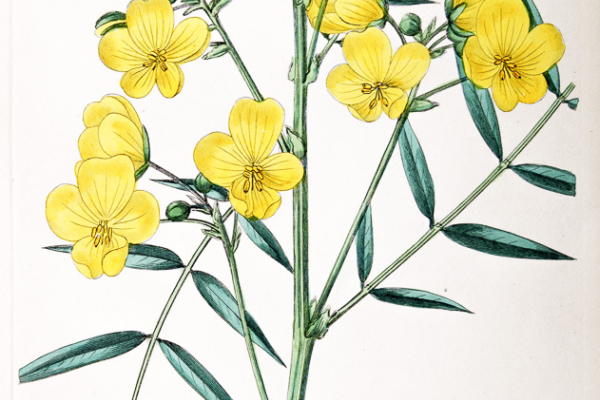
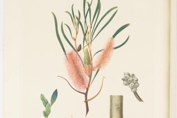
Robert Sweet's Flora Australasica 1827-1828
Flora Australasica, or a Selection of Handsome and Curious Plants, Natives of New Holland, and the South Sea Islands containing Coloured Figures and Descriptions, London 1827-1828. This book contains one of the earliest and most comprehensive collections of the images and descriptions of Australian native plants published. Thought to be the first book where the images of Australian plants were taken from living specimens (grown in London) rather than dried plants.

Giles, Ernest -The journal of a forgotten expedition in 1875
This volume, reprinted from the Adelaide Observer in 1880, is of historical significance as one of the major works of this important Australian explorer and is personally annotated by the author.
It is a record of Giles' third expedition in 1875 to the west of South Australia.
Humboldt and Bonpland, Voyage de, Atlas Historique, 1810
Humboldt, Alexander von (1769-1859), Voyage de Humboldt et Bonpland, Premiere Partie, Relation Historique, Atlas Pittoresque, 1810 or Vues des Cordilleres, et monuments des peuples indigenes de l'Amerique.
This large luxury edition is important because it gives a picture of the landscapes and cultures of South America in early colonial times. It has illustrations of indigenous statues and hieroglyphs as well as colonial buildings and settlements. Cordilleres is the Spanish word for network or chain of mountains. The text of this publication is in French.
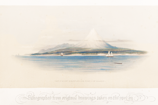
Adventures in New Zealand Illustrations by Mrs Wicksteed, 1845
Wakefield, Edward Jerningham, Illustrations to Adventures in New Zealand lithographed from original drawings taken on the spot by Mrs Wicksteed et al. Smith, Elder 1845. These illustrations accompany Adventures in New Zealand and include coloured lithographs of landscapes, Maori people and buildings and the beginnings of colonisation. They form an important record of New Zealand at that time. Included are a number of large fold out pictures giving panoramic views of the landscape.
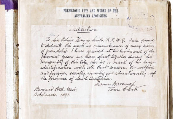
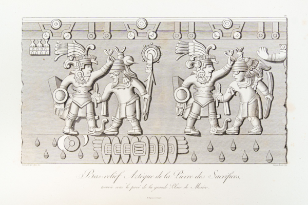
Worsnop, Thomas - Prehistoric Arts, Manufactures, Works, Weapons, Etc., of the Aborigines of Australia. galley proof, 1893
Together with the South Australian Museum, the Society holds the annotated proofs for Worsnop’s ground-breaking book, published in 1897 as the first continental survey of Aboriginal art and creative expression. ‘I have endeavoured to show’, wrote Worsnop, ‘that Australia is not barren in pictography … and by comparison with the works of other nations to secure for our aborigines a due appreciation of their undoubted artistic nature’.
James Webber's Views of the South Seas, 1808
Webber James (1752-1793), Views of the South Seas from drawings by the Late James Webber, Draftsman on Board the Resolution with Captain James Cooke*, from the year 1776 to 1780.
Webber produced the most comprehensive visual record of the Pacific made to that time. This publication is important because it contains beautiful hand-coloured softground etchings of native sailing craft, landscapes, village scenes and people with accompanying descriptions taken from Cook's Last Voyage.
* There is some confusion over names. The title page carries the names James Webber and Captain James Cooke. The former is usually referred to elsewhere as John Webber and the latter always as Captain James Cook.

John Hawkesworth's account of four voyages to the Pacific including Cook's first voyage around the world
This first edition is a rare and interesting treasure which includes the official version of Lieutenant James Cook's momentous first voyage (1768-1771) around the world. However, Hawkesworth's edited account was contentious in some respects and was criticized strongly by Alexander Dalrymple and by James Cook himself.
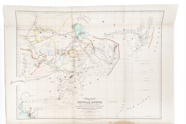
Central Africa Maps and Illustrations, 1854
Richardson, Barth, Overweg and Vogel, by Authority of Her Majesty's Foreign Office, compiled by Augustus Petermann FRGS 1850, 1851, 1852 and 1853, An account of progress of the expedition to Central Africa, Consisting of Maps and Illustrations with Descriptive Notes, London 1854. This is an important book describing the remote region south through the Sahara to Sudan compiled by the very well known and well-regarded cartographer and publisher Augustus Petermann.
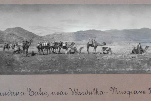
Richard T. Maurice’s album of photographs, ‘Fowlers Bay to the Cambridge Gulf’ expedition, 1902.
This photograph album documents a remarkable, 3,000 kilometre expedition from Fowlers Bay to Wyndham on the Cambridge Gulf, via Uluru. It was funded and led by one of Australia’s most experienced, if least known, explorers, Richard Thirlwell Maurice (1859-1909). The distinctive panoramic photographs in the album were probably taken with a recently issued #4 Kodak Panoram panoramic camera. The photographs include images of a chain gang of Aboriginal prisoners (men and women) at Wyndham. The images were published in southern newspapers and attracted considerable controversy.

Schomburgk's twelve views of Guiana, 1841
This is an important example of the artwork made by explorers before photography was in general use. The full title is Twelve views in the interior of Guiana from drawings Executed by Mr Charles Bentley, after sketches taken during the expedition carried on in the years 1835 to 1839, under the direction of the Royal Geographical Society of London and aided by Her Majesty’s Government, with descriptive letterpress by Robert H Schomburgk Esq. Accompanied by illustrations on wood, London, Ackerman and Co. 96 Strand, 1841.
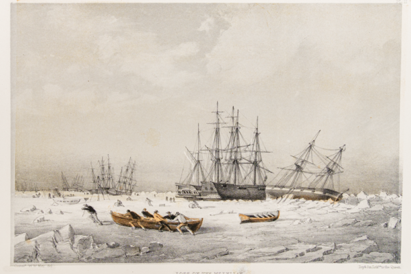
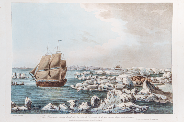
Cmdr Walter May's A Series of Fourteen Sketches, 1855
May, Commander Walter William, RN, A Series of Fourteen Sketches, Made on the Voyage up Wellington Channel in Search of Sir John Franklin KCH and the Missing crews of HM Discovery and Ships Erebus and Terror, London 1855.
Walter May was a marine watercolourist known for his fine coastal scenes and images of boats and ships. This treasure provides a record of the expedition commanded by Sir Edward Belcher which was the last in a series to find Sir John Franklin who was lost searching for the North West Passage.
One of the ships on the Belcher expedition was HMS Resolute, some of the timbers from which were used to make the Resolute desk, which has been located in the Oval Office of the White House for many years.

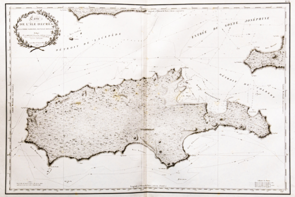
Olfert Dapper - Description Exacte des Isles de L'Archipel, 1703
Written in French and published in Amsterdam, this is an example of a very early "travel " book of the times with fine detailed and decorative maps.
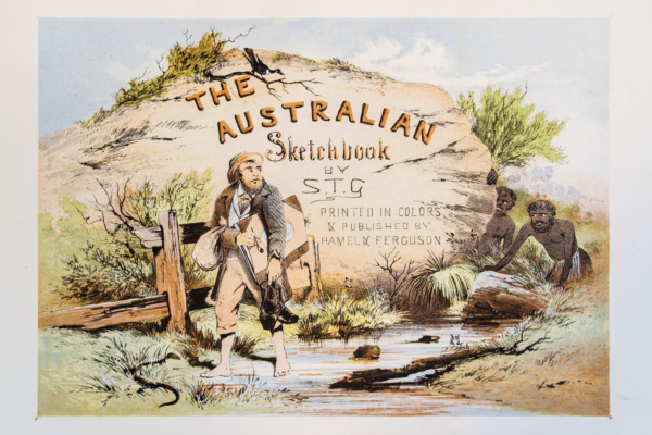
S T Gill - prints from 'The Australian Sketchbook'
A collection of prints from The Australian Sketchbook by S T Gill published by Hamel and Ferguson, Melbourne, 1864-1865. These original prints are remarkable for the brightness of the colours and the lively depiction of the characters.
S T Gill is one of Australia's best known and admired artists of colonial life and particularly that of the gold fields.
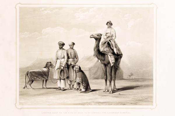
Emily Eden's Portraits of the princes & people of India, 1844
Portraits of the princes and people of India, 1844 by The Honourable Emily Eden (1797-1869) published by J. Dickinson & Son, London.
This large folio edition drawn and published by a talented woman artist and novelist was most unusual in those times. Emily Eden was a correspondent of Queen Victoria.
Voyage of the Astrolabe by J S C D D'Urville. 1833
D'Urville, Jules Sebastien Cesar Dumont, Voyage de la Corvette L'Astrolabe Execute par ordre du Roi, pendant Les Annees 1826-1827-1828-1829 sous le Commendement de J. Dumont D'Urville. Atlas Hydrographique. Paris J. Tastu 1833.
This rare first edition elephant folio size hydrographic atlas records the first voyage of the Astrolabe (1826-1829) around the world including visits to Australia, Port Jackson, New Zealand, Fiji, New Guinea, New Britain, and many other Pacific islands.
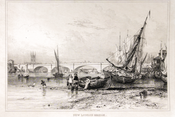
Cooke's Views of Old and New London Bridges 1833
Views of the Old and New London Bridges, With Scientific and Historical Notices of the Two Bridges and a Concise Essay on Bridges by George Rennie Esq. FRS FAS. Drawn and etched by Edward William Cooke, London, 1833.

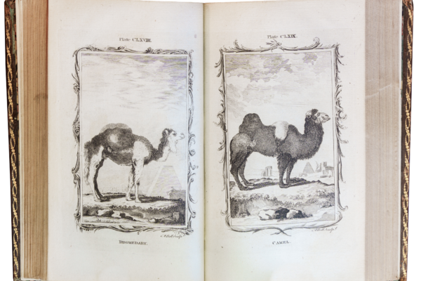
Tortoises, Terrapins and Turtles, Drawn from Life by J C Sowerby and E Lear with text by J E Gray, 1872
This is considered one of the best collections of illustrations of tortoises, terrapins and turtles ever produced with the brilliant lithographs by Edward Lear based on the illustrations by James de Carle Sowerby. It is based on the writings of Thomas Bell who was Professor of Zoology at King's College London from 1835.

Pomona, or the Fruit - Garden Illustrated, 1729
This very early book, beautifully illustrated with 79 plates, includes many aspects of establishing and maintaining fruit gardens and the cultivation of many different fruits. Pomona was the Roman Goddess of fruit trees, abundance and plenty.

David Collins, An account of the English colony of NSW, 1798
An Account of the English Colony in New South Wales, with Remarks on the Dispositions, Customs, Manners etc. of the Native Inhabitants of that Country by David Collins Esq. late Judge Advocate and Secretary of the Colony, London, 1798. David Collins (1756-1810) arrived in Sydney Cove with the First Fleet in 1788 and was responsible for establishing the colony's legal framework. This was a vital contribution to the success of the new colony enabling it to be administered on a relatively orderly basis. These two volumes are first editions and provide an important record of the history of the establishment of the colony of New South Wales.

Cawthorne, William - Legend of the Red Kangaroo
The Legend of Kuperree or the Red Kangaroo: an Aboriginal tradition of the Port Lincoln tribe.1858. William Cawthorne was a schoolmaster who emigrated to Adelaide in 1841. He took a special interest in the traditions of the Aboriginal people and their relations with the white settlers. This first edition is very rare and of particular interest as it has annotations by the author.
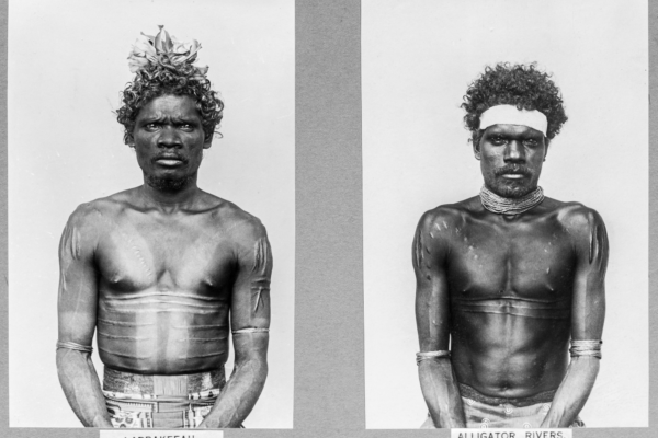
Paul Foelsche’s portrait photographs of Aboriginal people of the Darwin region, 1880s.
Paul Heinrich Matthias Foelsche (1831-1914) was the first resident photographer in Australia’s ‘Top End’. He was also its first police inspector, accompanying the Goyder Expedition to Port Darwin in 1869. His landscape and portrait photographs are windows onto the European-Aboriginal frontier of the late 19th century. Foelsche not only policed this frontier, but also recorded it, in fascinating detail.

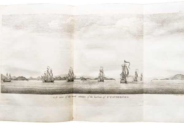
George French Angas, South Australia Illustrated, 1847
Published in 1847 by Thomas McLean in London, South Australia Illustrated is recognised as one of the finest folio volumes of nineteenth-century chromo-lithography. The volume was issued to subscribers in parts (six lithographs at ten two-month intervals); after twenty months their set of 60 plates was complete and could be bound in leather, as with the Society’s example.

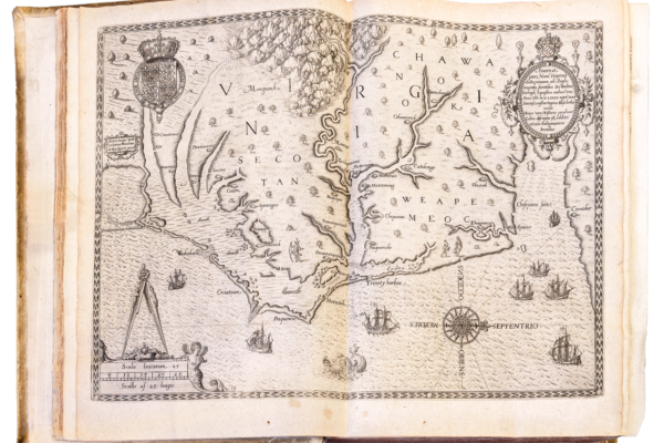
An early account of the British settlement in NSW, 1789
‘Officer’, An authentic and interesting narrative of the late expedition to Botany Bay: as performed by Commodore Phillips and the fleet of seven transport ships under his command, containing a circumstantial account of their perilous voyage, dissentions on board and safe arrival On the Coast of New Holland ... with ... descriptions of Jackson's Bay and Lord Howe's Island ... written by an officer just returned in the Prince of Wales transport.

The History of New South Wales, 1802
The History of New South Wales including Botany Bay, Port Jackson, Pamaratta, Sydney and all its dependancies from the Original Discovery of the Island with the Customs and Manners of the Natives and an Account of the English Colony from its Foundation to the Present Time, London, 1802. This book is believed to be the first written history of the settlement of NSW arguably written by one of the transported convicts, George Barrington who arrived with the Third Fleet in 1791.
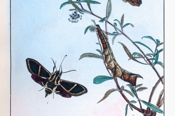
John Lewin's Natural History of Lepidopterous Insects (i.e. moths) of NSW, 1805
This book by John Lewin (1770-1819) was the first natural history book illustrated with plates produced in Australia and is extremely rare.
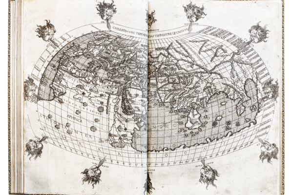
Ptolemy atlas 1480 - Ptolemy, Claudio, AD 100- AD 168 Geographia di Francesco Berlinghieri 1480
The oldest book in the Society’s Library is Ptolemy's Geographia di Francesco Berlinghieri, a folio volume published in Florence, Italy, by Nicolo Todescho Berlinghieri, ca 1480. This volume contains the calculations and art works of Claudius Ptolemy, 100 – c. 170 AD with 31 maps engraved on copper and is considered a monument of typography and the engraver's art.

Maslen, Thomas John - The Friend of Australia 1830
Maslen, Thomas John. The friend of Australia or, a plan for exploring the interior and carrying on a survey of the whole continent of Australia, 1830.
This book is important as an early work to seriously consider the exploration of the interior of Australia and to include a layout for an "Australian Town" similar to that adopted by Colonel Light for Adelaide in 1836.
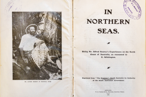
Mr. Alfred Searcy’s Experiences on North coast of Australia
This is an important cultural report with details of everyday life in Port Darwin (the 'Singapore of Australia') pre and post European settlement. It includes a history of the trepang (sea cucumber) trade and transport network and the social interaction between the local Aboriginal, Malay and Macassar peoples.
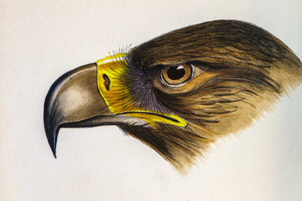
The Birds of Australia by John Gould
This set of volumes is recognised as one of the great natural history publications of all time. It was published between 1840 and 1848 with 681 hand-coloured lithographic plates and is an original edition.
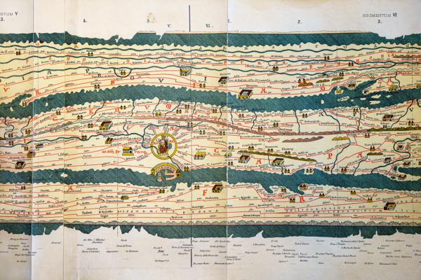
Peutinger Table - a 19th century copy of a strip map printed in 1598
This is a 19th century print of a 12th century copy of a map used by the Roman Empire to accurately transport goods and instructions to the regions under its control from around 27AD to 576AD. It is an important treasure being the only known map of the Roman Empire and ranges from the coast of the United Kingdom, through to, purportedly, the coast of China.

Elder Expedition 1891
This extensive collection of journals, scientific reports and early photographs belonging to the RGSSA is from the 1891 Elder Scientific Expedition to inland Australia. One of Australia's most professionally mounted expeditions, it was planned by the forerunner of the Royal Geographical Society of South Australia and financed by Sir Sir Thomas Elder. These are important historical and scientific records of inland areas not previously explored by Europeans and many new species of plants and animals were identified.
John White's Journal of a voyage to New South Wales 1788
John White’s Journal of a Voyage to New South Wales was published in 1790, and represents one of the earliest and most important first-hand accounts of Australian colonial history. It includes sixty-five plates of a wide variety of animals, insects, fishes and plants and is one of the rare editions in colour.
James Cook's first voyage around the world, 1768-1771
Captain James Cook's journal of his first voyage around the world 1768-1771 in HM Bark Endeavour, published in 1893 and edited by Captain James Wharton.
It was during this voyage that James Cook (1728-1779), then Lieutenant Cook, was the first to map the east coast of Australia. This rare limited edition has wooden covers said to have been made from "Cook's tree" on Clapham Common, London.

James Cook's second voyage towards the South Pole, 1772-1775
Captain James Cook's journal of his second voyage around the world. A Voyage towards the South Pole and Round the World performed in His Majesty's ships Resolution and Adventure 1772-1775.
Even though Cook had charted the east coast of Australia on his first voyage it was still thought by some that, even further south, a great south land of temperate climate may exist. By sailing far south and crossing the Antarctica Circle three times Cook established that this was not the case. This official limited edition journal was published in 1777.

James Cook's third voyage to the Pacific Ocean, 1776, 1778-1780
Cook, James, A Voyage to the Pacific Ocean in His Majesty's ships Resolution and Discovery, 1776, 1778, 1779 and 1780.
This was Cook's last voyage, the aim of which was to find the elusive Northwest Passage between the Pacific and Atlantic Oceans. They were not able to do this and on the return journey Cook was killed by the indigenous people in Hawaii. These three volumes, published in 1785 as a second edition, are treasures because they are the original record of this epic voyage.
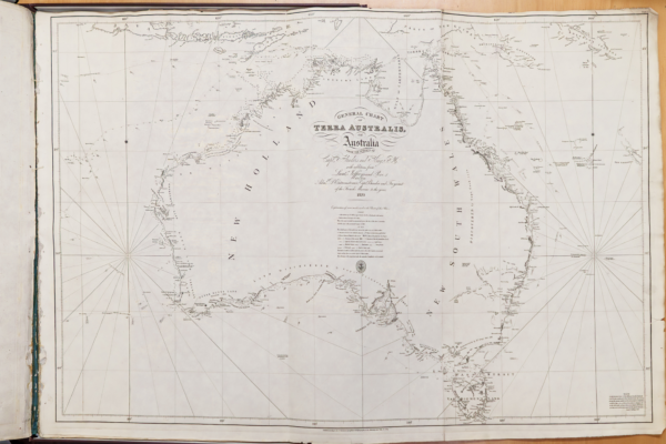
A Voyage to Terra Australis 1814, by Matthew Flinders
This rare edition, published as two volumes of journals and two volumes of charts in 1814, is one of the outstanding treasures of the RGSSA. Flinders was the first to circumnavigate Australia.
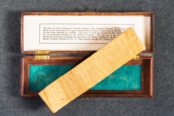
Space exploration poster & fragment of Stuart’s tree which travelled into space
This piece of wood from a tree blazed by renown explorer John McDouall Stuart was taken on the Endeavour voyage by Dr. Andrew Thomas (Australia’s only astronaut) as one of his personal mementos. The Society also has a framed collage celebrating NASA’s 1996 Space Shuttle Endeavour mission.
These items are unique and together represent a connection of exploration of both land and space by South Australians.
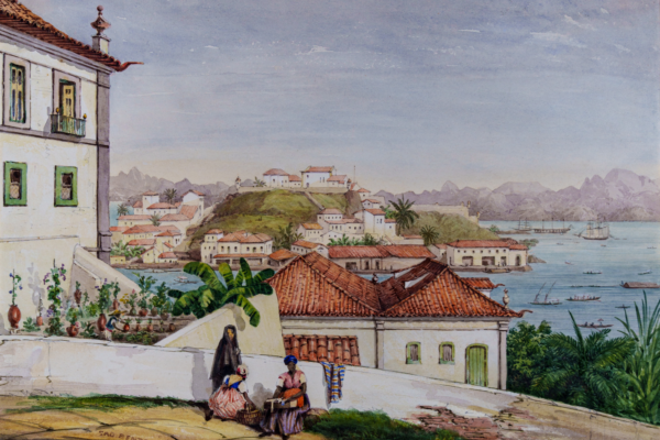
George French Angas - sketches of the Scenery of Rio de Janeiro
The eight finely drawn watercolours depict the scenery of Rio de Janeiro. George French Angas made these images in December 1845, during a short layover in Rio on his return voyage to England from Australia. George French Angas is well known for his major publication South Australia Illustrated - another RGSSA treasure.
A Collection of Voyages and Travels, 1704
First published in four volumes in 1704 by London booksellers Awnsham and John Churchill, these works were the first English translations of European explorations but also included English works that “for their excellency and scarceness, deserved to be reprinted”. These comprehensive volumes contained maps, engravings, and descriptions from voyages to much of the New World over the preceding two centuries.
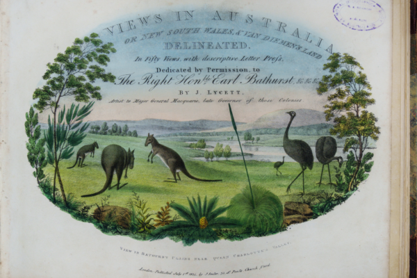
Views in Australia or New South Wales and Van Diemen's Land by Joseph Lycett, 1825.
Joseph Lycett was an artist who was transported to Australia in 1811 for forgery. His fifty aquatint engravings of landscape views are considered to be Australia's finest of the time and Lycett to be the outstanding artist of his period in Australia.
Peron's account of Baudin's voyage with maps by Freycinet
This treasure consists of three volumes written by Francois Peron and a collection of magnificent maps by Louis de Freycinet. These record the journey of exploration to the "south seas" under Capt. Nicholas Baudin between 1800 and 1804, which included the south coast of Australia. Among the maps is the first published map of the whole of the coastline of Australia. It was during this voyage that Baudin's and Mathew Flinders' paths crossed at Encounter Bay, South Australia in May 1802.
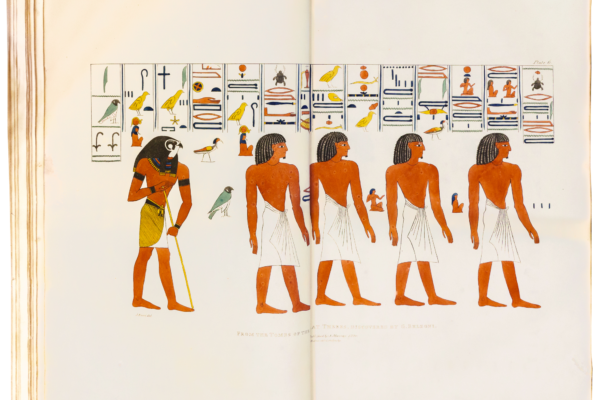
Plates Illustrative of the Researches and Operations of G. Belzoni in Egypt and Nubia. 1890.
This book belongs to the earliest attempts to document Ancient Egypt for a Western audience. Experts and the general public have relished it as a true treasure trove ever since it was first published in 1822. Belzoni’s incisive observations continue to be a rich source for archaeologists and ethnologists faithfully documenting sites and antiquities as they suddenly became accessible to the early 19th century discoverers from Europe and include sites not accessible to others.

Mark Twain's Life on the Mississippi, 1883
This first edition describes life on the Mississippi River both before and after the American Civil War.
Mark Twain recounts his colourful life as a steamboat pilot with a blend of fact and fiction incorporating both affection and humour.
De Bry’s collection of travels and voyages to America
During the 16th and early 17th century the De Bry family published some of the greatest collections of illustrated voyages to the Americas. Considered one of the most influential and sought-after collection of voyages and maps ever published.
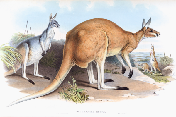
Mammals of Australia by John Gould, 1845 -1863
John Gould is usually thought of as the "bird man", but following his trip to Australia between May 1838 and August 1839, he published Mammals of Australia in three volumes with 182 beautifully hand coloured lithographic plates.
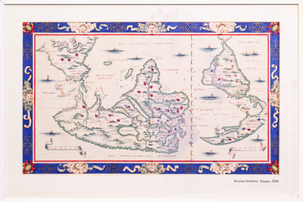
Mappemonde by Nicholas Desliens of Dieppe, 1566
This map was drawn with south at the top which was not uncommon until the use of the magnetic compasses became widespread. It is an excellent hand drawn copy from 1884 of one of the world’s oldest maps.
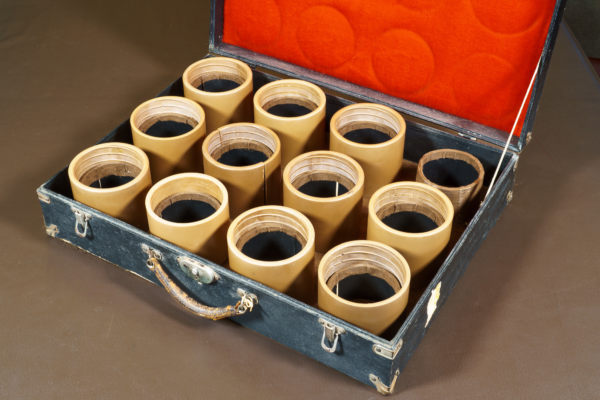
Spencer and Gillen Wax Cylinders of Aboriginal Songs
These twelve wax cylinders hold the earliest sound recordings ever made of Central Australian Aboriginal songs and language. The unique and priceless recordings were made by field anthropologists Walter Baldwin Spencer and Francis Gillen on their 1901-1902 expedition from Oodnadatta to the Gulf of Carpentaria.
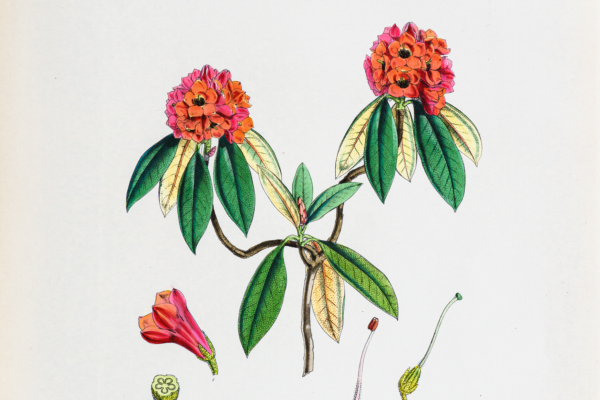
Hooker, Joseph Dalton - The Rhododendrons of Sikkim Himalaya, 1849
This beautiful and rare folio (489mm x 362mm) edition of the Rhododendrons of Sikkim Himalaya, 1849, contains 43 hand coloured lithographs of the rhododendrons collected by Joseph Dalton Hooker during his expedition 1847-1851 to the Himalayas.
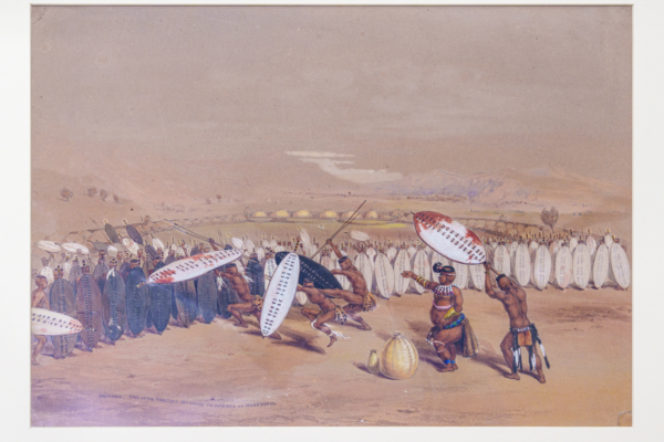
George French Angas - Sketches by Hand: The Kaffirs Illustrated
George French Angas is known for his meticulous depictions of South Australian and New Zealand people and landscapes, completed in 1845. His South African watercolours, painted during 1846-1847, are less well known. The Society holds ten of these works, combining accurate and engaging portraiture with close ethnographic observation.
Umpanda, King of the Amazulu, reviewing the soldiers at Nonduengu, 1847
The Forest Flora of South Australia - 45 coloured botanical lithographic plates
The Forest Flora of South Australia contains the first high quality prints of local botanical specimens published in the province of South Australia. Issued in nine parts, each of five plates, between 1883 and 1890.
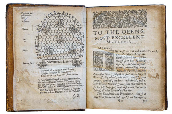
Charles Butler's The Feminine Monarchie, or the Historie of Bees, 1634
This is the first known work on the science of beekeeping in the English language. Written by Charles Butler, who is known as the Father of English beekeeping, the text brought into the public consciousness the idea that a bee colony is presided over by a queen.
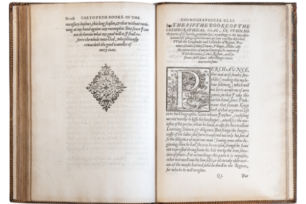
William Cuningham's Cosmological Glasse 1558
The Cosmological Glasse, conteinyng the pleasant Principles of Cosmographie, Geographie, Hydrographie or Navigation, 1558. This very old and important book is said to be the first written on the subject of surveying and is one of the oldest items in the RGSSA collection. It contains many beautiful woodcuts including an aerial view of Norwich.
The Zincali by George Borrow
This manuscript is in book form and consists of drafts for 'The Zincali' or An Account of the Gypsies of Spain published in1841 and also notes by the author George Borrow.
Image from The Project Gutenberg eBook of The Zincali
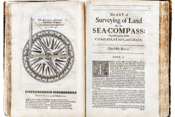
The Mariners' Magazine - By Captain Samuel Sturmy (1633-1669)
This 1679 publication is a comprehensive text covering all aspects of navigation. Included are logarithmic tables, instructions in astronomy, geometry, trigonometry, latitude and longitude as well as "fireworks" and fortifications.
It also includes a number of unusual rotating circular paper calculators - forerunners of the circular slide rule.
It is one of the oldest books in the Treasures collection.
Colom, Arnold, Zee Atlas - Amsterdam 1658
This rare atlas, mostly of charts, includes one of the earliest published maps showing part of the south coast of Australia. These charts are exceptionally beautiful with ornate cartouches and vivid colouring.
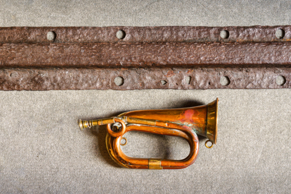
Sample of the original rail line from Goolwa to Port Elliot Railway
This rail sample from the Goolwa to Port Elliot section, opened in May 1854, is a first in Australia for several reasons: first laid with iron rails; first Government funded railway; first to use the 5’3’’ gauge in South Australia. The bugle is unique in that it belonged to the driver, as the line only used animal power, so there was no steam whistle.
South Australia, wall map, created by the Department of Lands 1923
This 1923 map, a one-off creation, is approximately 3 metres wide by 3.5 metres tall, and has the signature of the Surveyor General, Theo (Theodore) E. Day, who was appointed in 1921. The map is a good example of the cartographer’s art around the 1920s. It includes the routes of 28 explorers from Charles Sturt 1823 to Frank Rees George 1904 as well as Surveyed Lands, Pastoral Leases, Artesian basins and Goyder’s Line of rainfall etc.
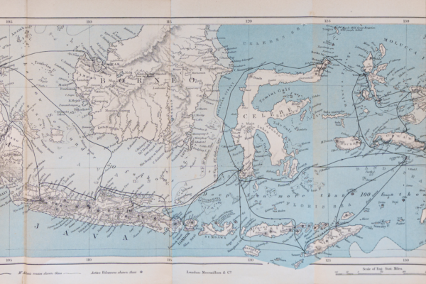
Wallace, Alfred Russel, The Malay Archipelago, 1869 and The geographical distribution of animals, 1876
These first editions are important treasures because they were written by Alfred Russel Wallace who developed theories of evolution and survival of the fittest at about the same time as Charles Darwin. Wallace also developed the "Wallace Line " running north south between Borneo and the Celebes that recognised the clear separation of Asiatic and Australian animals.
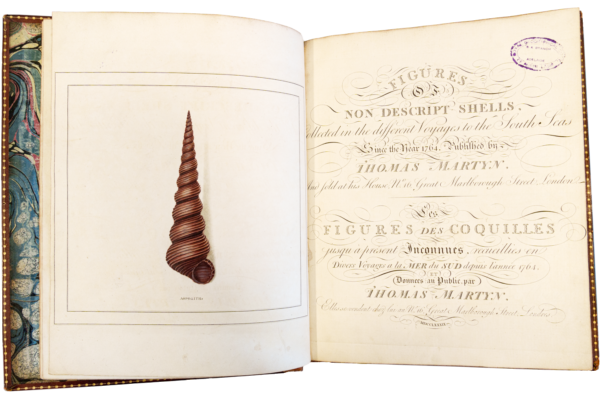
Thomas Martyn's The Universal Conchologist, 1789
Martyn, Thomas, Figures of Non-Descript Shells, Collected in the different voyages to the South Seas since the year 1764, and sold at his house at 16 Great Marlborough Street, London. 1789. Sub-title The Universal Conchologist.
This is the scarce "South Seas" edition published as two volumes after the original 4 volume edition The Universal Conchologist, 1784.
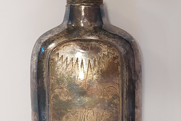
McKinlay’s Whisky Flask
Known as the "knight-errant of explorers", and standing 193cm (6 feet, 4 inches) tall, Scotsman John McKinlay (1819-72) was an adventurer and pastoralist. He led the South Australian Burke Relief Expedition and was the second European to cross the continent from south to north.
Catalogue of specimens of cloth collected during the voyages of Captain Cook, 1768-1779
This small book produced by Alexander Shaw in 1787 contains 38 samples of tapa cloth collected on the three voyages of Captain Cook to the South Pacific 1768-1779.
It is a rare example of items known to have certainly been on Cook's ships. It also contains anecdotes of early encounters with Indigenous peoples.
A Synopsis of the Birds of Australia and Adjacent Islands by John Gould 1837-1838
This is an original edition of John Gould's first venture into the study of Australian birds featuring artwork and lithography by Elizabeth Gould. It contains seventy three hand-coloured lithographic plates showing mainly the heads of more than 160 Australian birds.
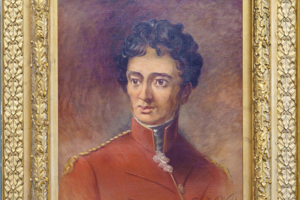
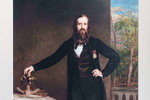
Colonel Light's surveyor's level and portrait
Colonel William Light (1786-1839) was responsible for choosing the site and laying out the City of Adelaide in 1836 and has been called the "Founder of Adelaide". The Society is fortunate to have a portrait of Light by George A J Webb as well as his surveyor's dumpy level and relics salvaged from his cottage.
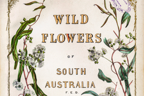
Wildflowers of South Australia by Fanny de Mole, 1861
Wildflowers of South Australia was written and illustrated by Fanny Elizabeth de Mole (1835 - 1866). Published in 1861, it was the first book published on the botany of the province of South Australia.

South Australia as a place of residence for Anglo-Indians by J L Parsons and T Harry, 1892
This publication is in hand written script and was issued by the Anglo-Indian Colonisation, South Australian Board of Advice and Correspondence which had a board of eleven prominent citizens including an influential figure, Hon. Langdon Parsons MP.
It is a rare example of the literature seeking the immigration of Anglo-Indians, and has an association with an influential figure in both South Australian and Northern Territory history. This volume is inscribed: ‘T. Gill Esq, with the compliments of the authors’, and is therefore particularly rare being annotated by the authors.
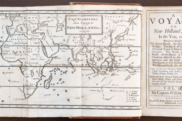
Dampier, William, A voyage to New Holland, &c. in the year 1699, Vol. III
This is a record of Dampier's second voyage to Australia as master on board the HMS Roebuck and was published in London in 1703. It is of historical significance as an early work (pre 1800) of voyage, exploration and description of Australia. It also contains the first drawings of a number of Australian plants including Sturt’s desert pea.
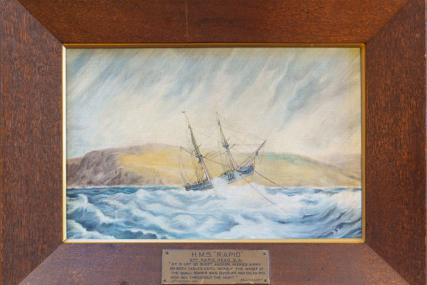
Painting of Colonel Light’s ship H.M.S. Rapid in a gale at Rapid Bay
This oil painting of the survey brig Rapid, painted by Miss Doreen Bice, is a copy of an original watercolour by Colonel William Light that depicts the ship riding out a storm while held by two anchors off Rapid Bay. The scene is described in Colonel Light’s journal for 12-13 October 1836 following Light’s return from exploring the Port River.
John Gould's Icones Avium 1837-1838
An original edition with 18 lithographs by John's talented artist wife Elizabeth. Features “figures and descriptions of new and interesting species of birds from various parts of the globe."
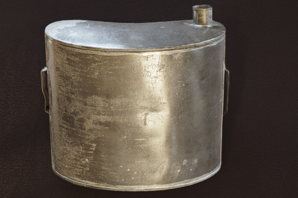
Coulthard’s Water Canteen
This water Canteen is emblematic of the unforgiving nature of the interior of Australia and the risks people took to reconnoitre the country. Pioneer William Coulthard died of thirst in 1858 while searching for pastoral country north of Port Augusta. He scratched his tragic last words on this canteen.

Conditions in the early days and a voyage to South Australia
Handasyde Duncan, The Colony of South Australia and W. B. Brown. Narrative of a Voyage from London to South Australia, 1850. These two pamphlets, published in the early days of the colony of South Australia, were influential in advising potential emigrants of conditions they could expect both on the voyage and on arrival. They were collected and bound together by Thomas Gill.
John Gould, Three papers on new species of birds, Transactions of Zoological Society, London
These papers, published in 1833 and 1847, are examples of the over 300 scientific papers by John Gould. They were published in the Transactions of the Zoological Society, London, and each has a hand-coloured lithographic plate of the subject bird, one of which was produced is by his artist wife Elizabeth Gould. These papers show that in 1833, early in his career, John Gould was well established in scientific circles as an ornithologist.

John Lewin's Book, Birds of New Holland, 1808
This book, by John Lewin (1770-1819), is extremely rare and is one of only six copies known to exist. It was one of the first books published on Australian birds. Also in this volume are six plates from Lewin's Natural history of lepidopterous insects.
James Poole's Grave - oil painting
Oil painting of James Poole's grave at Depot Glen between Tibooburra and Milparinka NSW. Poole was second in command of Charles Sturt's expedition and died in July 1845 from scurvy.
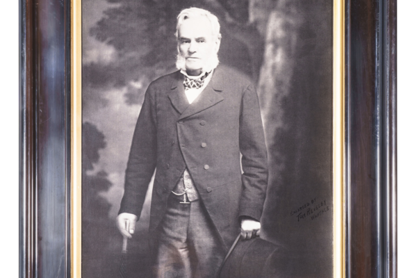
Portrait of William Silver and the York Gate Library
This portrait shows William Silver, the founder of the York Gate Library, which forms an important part of the Royal Geographical Society of South Australia library located in the Mortlock Wing of the State Library of South Australia. This is the largest non-government specialist geographical collection in Australia and one of the most significant of its type in the world.
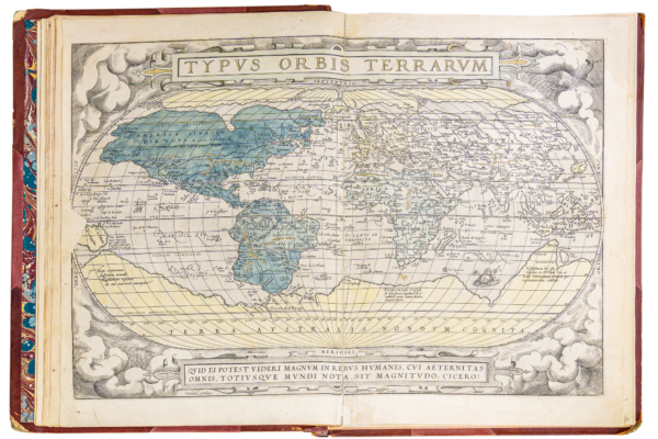
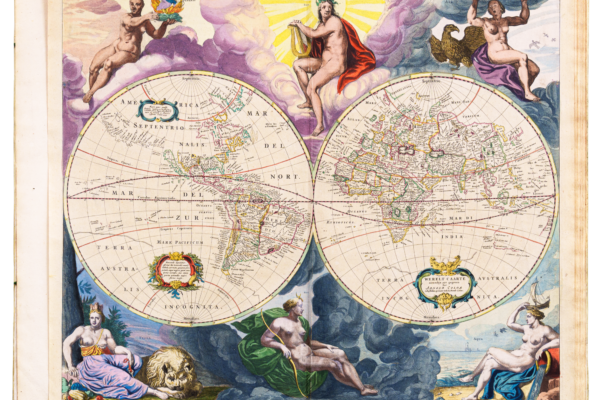
Theatrum Orbis Terrarum (Atlas of the Whole World) by Abraham Ortelius, 1571
This was a landmark in cartography and is known as the first modern atlas containing a comprehensive collection of the best available maps of the time.
Catalogue of the York Gate Library and its compiler Edward Augustus Petherick
The internationally significant York Gate Library was acquired by the RGSSA in 1905. Its catalogues, published in 1882 and 1886, are unusual being arranged by subject rather than by author.
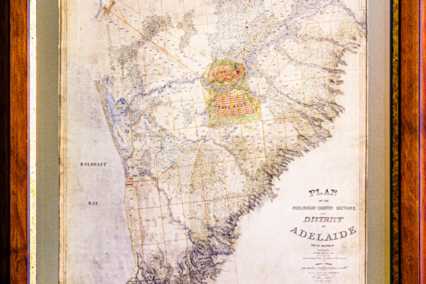
Nixon's map of Adelaide 1838
This very early map of Adelaide dated 1838 was drawn by Lieut. Henry Nixon who was a member of Colonel Light's survey party. It shows interesting detail of Adelaide in its very early days.
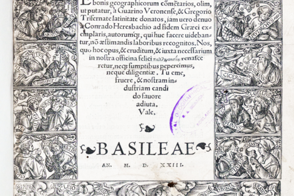
Translation of Strabo's Geographicorum 1523
This is a Latin translation of commentaries of Strabo's Geography presented by Valentmus Curio according to a new translation from the Greek original by Conrado Heresbachio,1523.
STRABO TRANSLATION, 1523 Lalentinvs Cvrio lectori. En tibi lector stvdiose Strabonis geographicorum cõmetarios, olim ut putatur, à Guarino Veronense, & Gregorio Trisemate latinate donates, iam uero
A first edition of Sebastian Munster's 'Cosmographia Universalis' 1544
This was the earliest German language description of the world. It contains a wealth of pictorial detail illustrating towns, animals and human beings as well as the more usual geographical information. It is one of the oldest books in the RGSSA library.
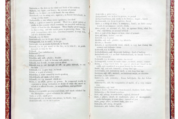
Teichelmann CG and Schürmann CW - Outlines of a Grammar, Vocabulary and Phraseology of the Aboriginal Language of South Australia
This vocabulary and grammatical description of the original Adelaide Plains language (now known as ‘Kaurna’) was published in 1840 by Lutheran missionaries C.G. Teichelmann and C.W. Schürmann. It is a treasure for both Kaurna descendants and linguists. The reclamation of Kaurna, evident in recent re-namings of the city’s parklands and buildings, for instance, could not have occurred without the missionaries’ work.
Comte de Buffon, Georges Louis Leclerc, Natural history, general and particular Illustrated, 1785
Buffon was the greatest naturalist of his time and some of his thoughts on how the world developed pre - dated those of Charles Darwin by 100 years. These RGSSA volumes are of historical significance for their early date of publication and the renown and influence of their author.
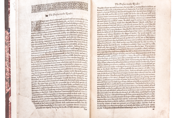
Purchas his Pilgrimes in four volumes, 1625
Published in 1625 by Samuel Purchas - an Anglican cleric who met many seafarers in the course of his work. He collected their stories and published them as a way of educating the public and spreading the gospel. The book was a favourite of the author Samuel Taylor Coleridge (1772-1834) and the inspiration for his famous poem Kubla Khan.
Haklvytvs postumus,or, Purchas his Pilgrimes: contayning a history of the world, in sea voyages, & lande-trauells by Englishmen and others, whereinn Gods wonders......1625
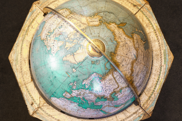
Terrestrial globe 1857
A good quality terrestrial globe but not sufficiently reliable to prevent New Guinea being shown as two islands!
Maquette and framed portrait of explorer John McDouall Stuart
Described as Australia’s greatest inland explorer, John McDouall Stuart led six expeditions across Australia, becoming the first European to cross the continent from south to north and returning without loss of life. Stuart’s six trips from 1858 to 1963 solved the global geographical riddle of what was in the centre of Australia and answered the question of the presence of an inland sea.
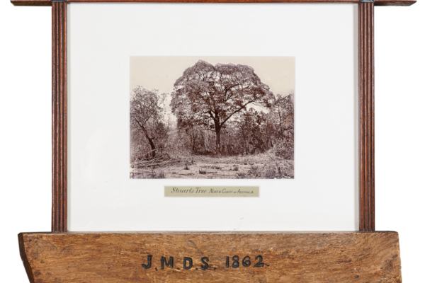
Stuart's Tree - images
The painting of John McDouall Stuart's Tree at Chamber's Bay, NT celebrates the first south-north crossing of the Australian continent.
John McDouall Stuart’s diaries
These two manuscript diaries were made by Stuart during his penultimate crossing of Australia November 1860 to July 1861 and July to September 1861. His next and last crossing was successfully completed during 1861-62 and he arrived back in Adelaide in early 1863. No other manuscripts exist.
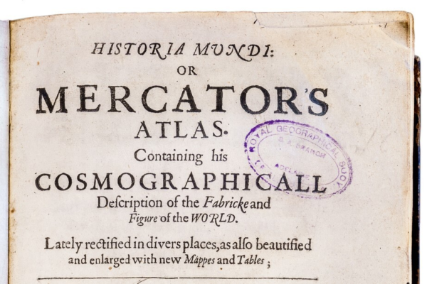
Historia Mundi: or Mercator’s Atlas – in English, published London, 1635
Gerardus Mercator (1512-1594) was a Flemish geographer, engraver and mathematician renowned for his production of maps, globes and scientific instruments. His Atlas, first published (posthumously) in 1595, represents the first appearance of the word ‘Atlas’ to reference a book of maps.
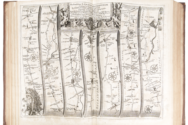
John Ogilby's Principal Roads - Britannia, 1698
Britannia or the Kingdom of England and Dominion of Wales, Actually Survey'd with A Geographical and Historical Description of The Principal Roads, published by Abel Swall and Robert Morden, London, 1698. First published in 1674, this volume is an atlas of strip maps similar to modern automobile association publications.
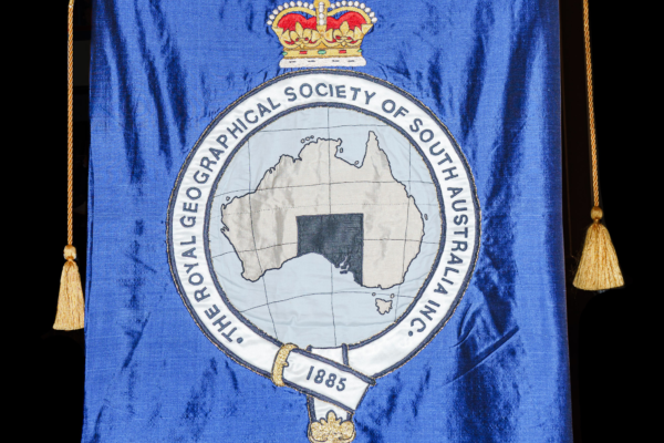
Royal Geographical Society of South Australia silk banner embroidered with gold and silver thread.
This banner was embroidered in 1986 by Mrs Eva Chambers, President of the Embroiderers' Guild of South Australia. The banner was presented to the Society on 10th July 1985 by President Brian Ward and his wife June at a special meeting of the Council held to mark the centenary of the formation of the Society on 10 July 1885.
Visscher, Nicolaes - Atlas Minor Geographia Orbis Terrarum, 1690
An important atlas by the famous Dutch Visscher family of engravers, cartographers and publishers who were prominent in the great period of Dutch map-making of the 17th century. Visscher atlases have some of the earliest detailed maps of the East Indies and Australia’s coast.

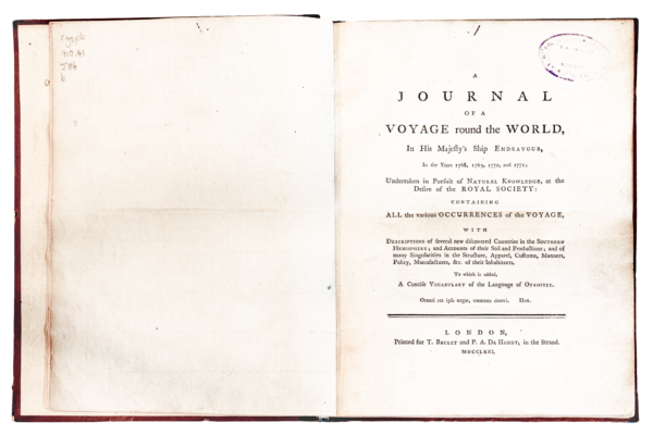
Sydney Parkinson's A Journal of a voyage to the South Seas in HMS Endeavour, 1773
Parkinson was Sir Joseph Banks' "draughtsman" on James Cook's expedition to Tahiti, New Zealand and Australia 1768 - 1771. This journal is based on the notes he made during the voyage and was published by his brother Stanfield after Sydney's death on the voyage home. The illustrations are engravings made from Parkinson's original sketches.
Matra, James Mario - A journal of a voyage around the world in His Majesty's ship Endeavour,1768-1771
In 1768 Matra joined Endeavour as a "Captain's servant" and sailed on the first voyage of Pacific exploration with James Cook and (Sir) Joseph Banks. When the Endeavour returned to England in July 1771 Matra had his journal published within a few months in contradiction of naval regulations so his name was suppressed. This extremely rare first edition provides some additional information and views to the official Admiralty record.
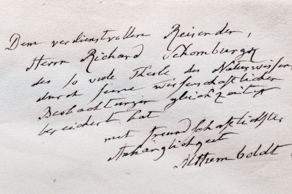
von Humboldt, Alexander - A first edition of Kosmos in two volumes, 1847
Von Humboldt (1769-1859) is said to be the greatest of the geographer - explorers of the nineteenth century. This first edition of Kosmos in two volumes (Kosmos : Entwurf einer physischen Weltbeschreibung) includes a dedication to Richard Schomburgk which gives this treasure a direct connection between Adelaide and the international science community.
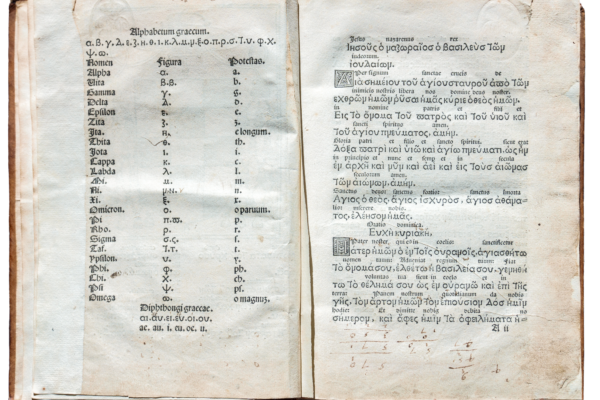
Chrysoloras, Manuel (1335-1415) - Greek- Latin Grammar 1514
This very old Greek- Latin Grammar or Erotemata was prepared by Chrysoloras and edited by Demetrius Ducas in 1514. It is said to be the first book printed in Greek in the Western World.
(Erotemata chrysolorae. De formatione temporum ex libro chalcondylae.: Quartus gazae de constructione. De anomalis verbis. De encliticis. Sententiae monastichi ex varijs poetis..1514 )
Pliny the Elder AD 23-79; The historie of the world
Commonly called the Natvrall historie of C. Plinivs Secvndvs; Plinies naturall historie. 1601; Uniform Title: Naturalis historia. English. 1601; Translated into English by Holland, Philemon 1552-1637; this extremely old and rare publication was published in 1603.
Jomard Atlas, 1854
This oversized atlas contains hand coloured lithographs of some of the world's earliest and most famous maps. They were published in 1854 by Edme Francois Jomard (1777-1862) curator of geography and maps at the Bibliotheque royale, Paris. Jomard's consuming interest was the history of maps and cartography.
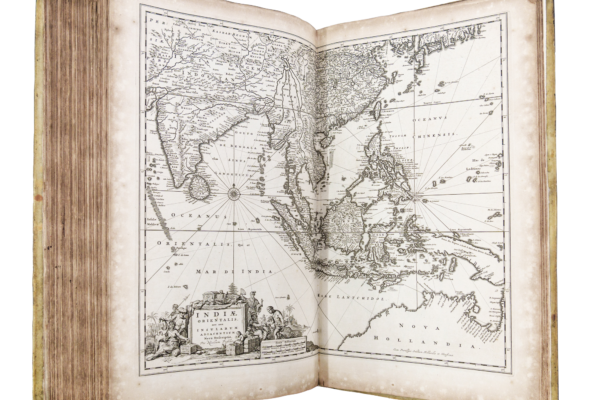
Van de Velde, Charles W. M.; Vues de Java, Sumatra, Borneo, Celebes published in Amsterdam in 1846
Van de Velde, Charles William Meredith (1818-1898), Vues de Java, Sumatra, Borneo, Celebes published in Amsterdam in 1846. This rare and beautiful French first edition contains some of the earliest printed views of the Indonesian Islands printed in Europe.

Charles Sturt, Narrative of an Expedition into Central Australia,1849
Captain Charles Sturt FLS, FRGS, Narrative of an expedition into Central Australia , performed under the authority of Her Majesty's Government, during the years 1844, 5 and 6.
These two volumes are particularly rare having, on the title page, Sturt's personal inscription to his son Charles on his departure for Bombay. They are also notable for the coloured lithographs of birds and animals by John Gould, famous for his large folio publications of birds such as Birds of Australia.
Birdsville Track - early map by Police Trooper Samuel Gason, 1873
This hand drawn map is thought to be the earliest of the Birdsville Track and surroundings and is therefore an important part of Australia's history.
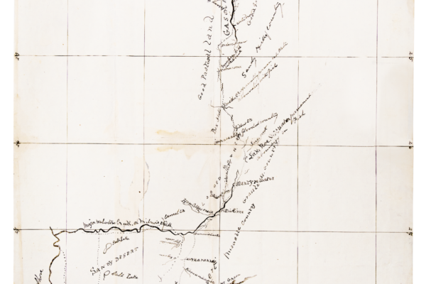
Diaries of Expedition to Ayers Rock, 1873 - Gosse and Berry
This treasure consists of two diaries - the original diary of William Gosse from his expedition to Central Australia and his discovery of Ayers Rock (the first by a non-indigenous explorer), and the diary of the expedition's second in command Edwin Berry.
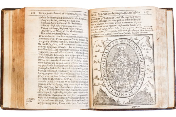
Lithgow's Travels 1632
The Totall Difcourfe, Of the Rare Adventures, and painefull Peregrinations of long nineteene Years Travayles, from Scotland to the most famous Kingdoms in Europe, Asia and Affrica, published London, 1632.
Lithgow's account is significant because it provides a record, not only of the cities and regions visited, but also of some of the customs of the time.
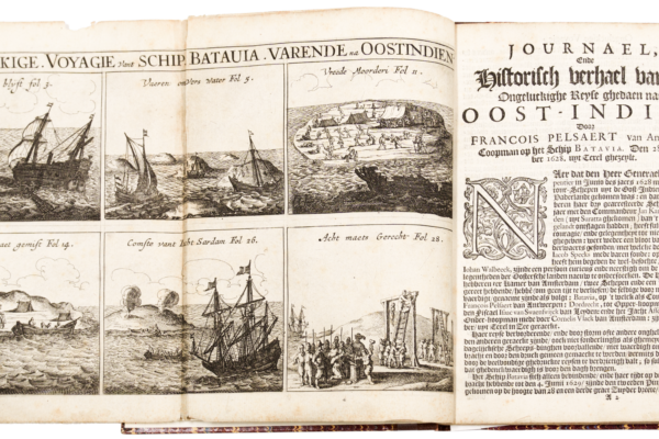
Pelsaert's account of the wreck of the Batavia and subsequent mutiny, 1648
Francisco Pelsaert's journal chronicles the disastrous voyage and wreck of the Batavia on the coast of Western Australia and subsequent mutiny and massacre. It is extremely rare and valuable and is of historical significance as it describes some of the earliest recorded, and most notorious, events on the west coast of Australian in the mid 17th century.
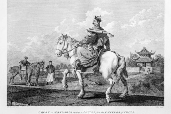
Earl Macartney’s Embassy to China, 1793
Earl Macartney’s Embassy to the Qianlong Emperor of China. An Authentic Account of an Embassy from the King of Great Britain to the Emperor of China. by Sir George Leonard Staunton, Earl George Macartney and Erasmus Gower, London 1793. This rare publication describes the first diplomatic mission by the British to China.

Poems and recollections of the past by Fidelia Hill, 1840
Fidelia Hill arrived in South Australia in the Buffalo in 1836 the same year that Colonel Light surveyed and established the City of Adelaide. Many of her poems reflect this background such as "Adelaide and other poems of South Australia " and "To the memory of Colonel Light."
This small volume of poems is an important historical record of the early days of South Australia and includes an interesting list of subscribers including the Lord Bishop of Australia.

Colom's Lighting Columne or Sea Mirrour
Colom, Jacob Aertsz, The Lighting Colomne or Sea- Mirrour, and a Short Introduction to the Art of Navigation. Amsterdam, 1670. This valuable and very early book combines navigation instructions and sea charts bound together. It is a translation into English from the Dutch.

Basil Hall in Corea
A voyage of discovery to the west coast of Corea ( Korea) by Captain Basil Hall RN, 1818.
This was the first description by the English of the west coast of what is now Korea. This book is very rare because it contains original pencil sketches, samples of oriental calligraphy, charts of the coastline as well as coloured plates showing the costumes of the people.
Hallewell's Views of the Bermudas 1848
These 13 beautiful prints are of Hallewell's watercolours made between 1842-1844 while he was posted in the army to Bermuda. They were issued in limited editions and are extremely rare being historically important as the most comprehensive and accurate set of views of Bermuda in Victorian times. They were lithographed by R Parrott, hand coloured and published in London in 1848.
Samuel Cresswell's coloured plates of the North West Passage
Cresswell, Samuel Gurney, A series of eight sketches in colour, together with a chart of the route of the voyage of HMS Investigator during the discovery of the North West Passage. 1854. These particularly fine coloured lithographic images show the dramatic icy conditions encountered by the crew in their voyage to the Artic 1851-1853, including the Investigator locked in the ice, and are important because this is the first record of the Northwest Passage.

Purry, Jean Pierre -Settlement at Terre de Nuyts
Purry proposed that the Dutch establish a colony on the Eyre Peninsular in South Australia which he suggested could have riches equal to those of South America. This was not accepted, but later the English gave him permission to establish a colony in Carolina, America. This book includes some early ideas for the establishment of colonial settlements in South Australia and Carolina.
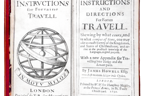
Howell, James - Instructions for foreign travel in 1650
Instructions and directions for forren travell: Shewing by what cours, and in what compass of time, one may take an exact survey of the Kingdomes and states of Christendome - London, 1650.
James Howell was Welsh and travelled widely throughout Europe and from his experiences wrote what we would now call a "travel guide". It is an early and rare example of a guide written at a time when travel had started to become more popular.

Destruction of the Indies by Bartholome de las Casas 1598
Casas was a Spanish Dominican friar who became Bishop of Chiapas and the first official "Protector of Indians".
This very early book, first published in 1552, is important for the influence it had on the abolition of the slavery of indigenous people in the Spanish colonies in the Indies.

Sonnerat, Pierre - Voyage a la Nouvelle Guinee, Paris , 1776
Pierre Sonnerat (1748-1814) was a French naturalist, diplomat and explorer who travelled widely in southeast Asia. He recorded and described many plants and animals, is honoured with the genus Sonneratia and was the first to describe the Chinese fruit tree lychee or Litchi Chinensi. This book is important for its early descriptions and illustrations of over 100 birds and animals.

Mandervile's Voyages and Travels 1704
Apparently written by an English knight, this book supposedly describes his experiences traveling in the Holy Land, Egypt, and the Far East. Illustrations show all sorts of wonders such as dog-headed men, Amazons and Pygmies. Written between 1357 and 1371, it was always extremely popular and is an example of how fact and fiction could be combined for the unsuspecting readership before the days of the great explorers.
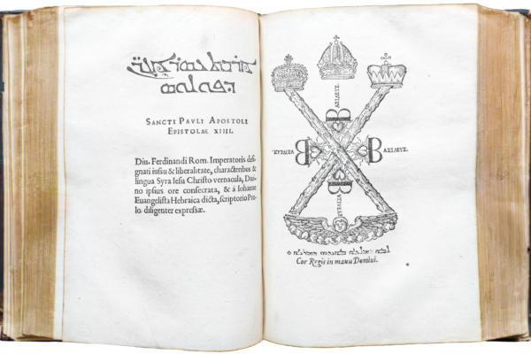
Syriac Bible 1555
This very early bible is written partly in Latin but mainly in the Syriac language which is a dialect of Middle Aramaic once spoken extensively across a large area of the Middle East known as the Fertile Crescent.
It is an important treasure because of its great age and the role it played in the spread of Christianity in the Middle East.
Dalrymple's historical collection of several voyages and discoveries in the South Pacific Ocean
Alexander Dalrymple was a Scottish geographer and hydrographer and a contemporary of James Cook and Joseph Banks.
This book is Dalrymple's major work by a man who made a substantial contribution to hydrography and the publication of significant numbers of charts for seafarers. He was a strong believer in the existence of a Great Southern Continent well before James Cook confirmed this in the Endeavour on his first voyage 1768-1771.

A letter from Mr Dalrymple to Dr Hawkesworth 1773
A letter from Mr Dalrymple to Dr Hawkesworth occasioned by Some groundless and illiberal Imputations in his Account of the late Voyages to the South, London 1773.
Alexander Dalrymple objected to aspects of the way Hawkesworth had edited Lieutenant James Cook's journals of his first voyage around the world. This is an original publication of the open letter and very rare and is inscribed "From the author -". It gives an interesting insight into the politics of London society at the time of the discovery of Australia.

Labillardiere's Voyage in Search of La Perouse
Voyage in Search of La Perouse 1791-1794 by M Labillardiere, 1800. The French scientific expedition commanded by Jean-François de Galaup de la Perouse sailed from Port Jackson on 10 March 1788 never to be seen again by Europeans. A subsequent rescue expedition with Jacques-Julien Houtou de Labillardiere as naturalist on board resulted in this account. It is one of the most dramatic stories in maritime history and these volumes are rare first editions.

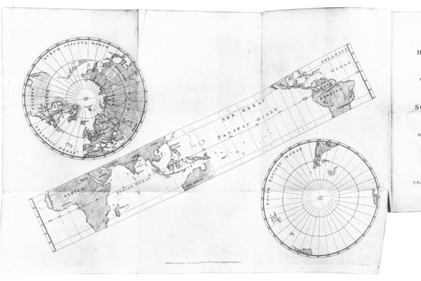
Vancouver's Voyage of Discovery, 1798
Vancouver, Captain George, A voyage of discovery to the north Pacific Ocean and Round the world in which the coast of north west America has been carefully examined and accurately surveyed. Undertaken by His Majesty's Command, Principally with a view to ascertain the existence of any navigable communication between the North Pacific and North Atlantic Oceans, and performed in the years 1790, 1791, 1792, 1793, 1794 and 1795 in the Discovery sloop of war and Armed tender Chatham, under the command of Captain George Vancouver. London, 1798. This account in 3 volumes includes the first very detailed description and extraordinary charting of the complex northwest coast of America.
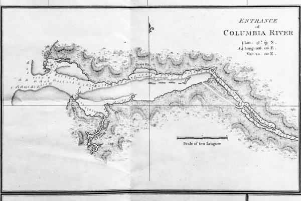
Captain George Vancouver's charts of the Northwest Coast of America.
These are exceptional charts to be read in conjunction with the RGSSA Treasure Captain George Vancouver, A Voyage of Discovery to the North Pacific Ocean and around the world.
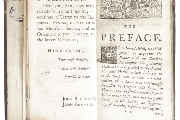
Bulkeley and Cummins - loss of HMS Wager, 1743
Bulkeley, John and Cummins John, A voyage to the South Seas in the years 1740-1 a faithful narrative of the loss of the His Majesty's Ship the Wager. This journal, written by ordinary seamen, not officers, is rare and was published without the official approval of the Admiralty.
Anson, George - A voyage around the world 1740-1744
Compiled by Richard Walter MA, Chaplain to His Majesty’s ship Centurion with 42 Copper plates. Of special interest are the images and maps by 2nd Lieut. Peircy Brett. These engravings are remarkable for their extent, variety and accuracy.