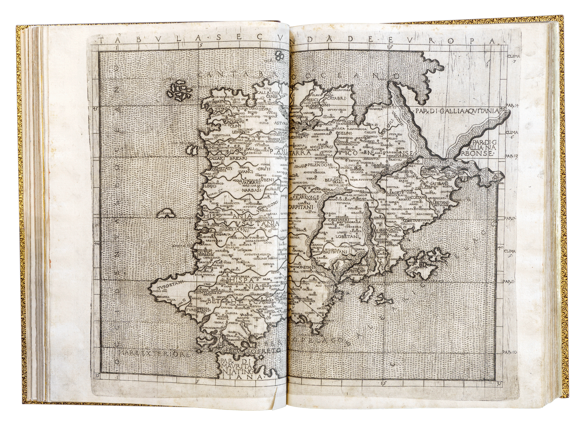
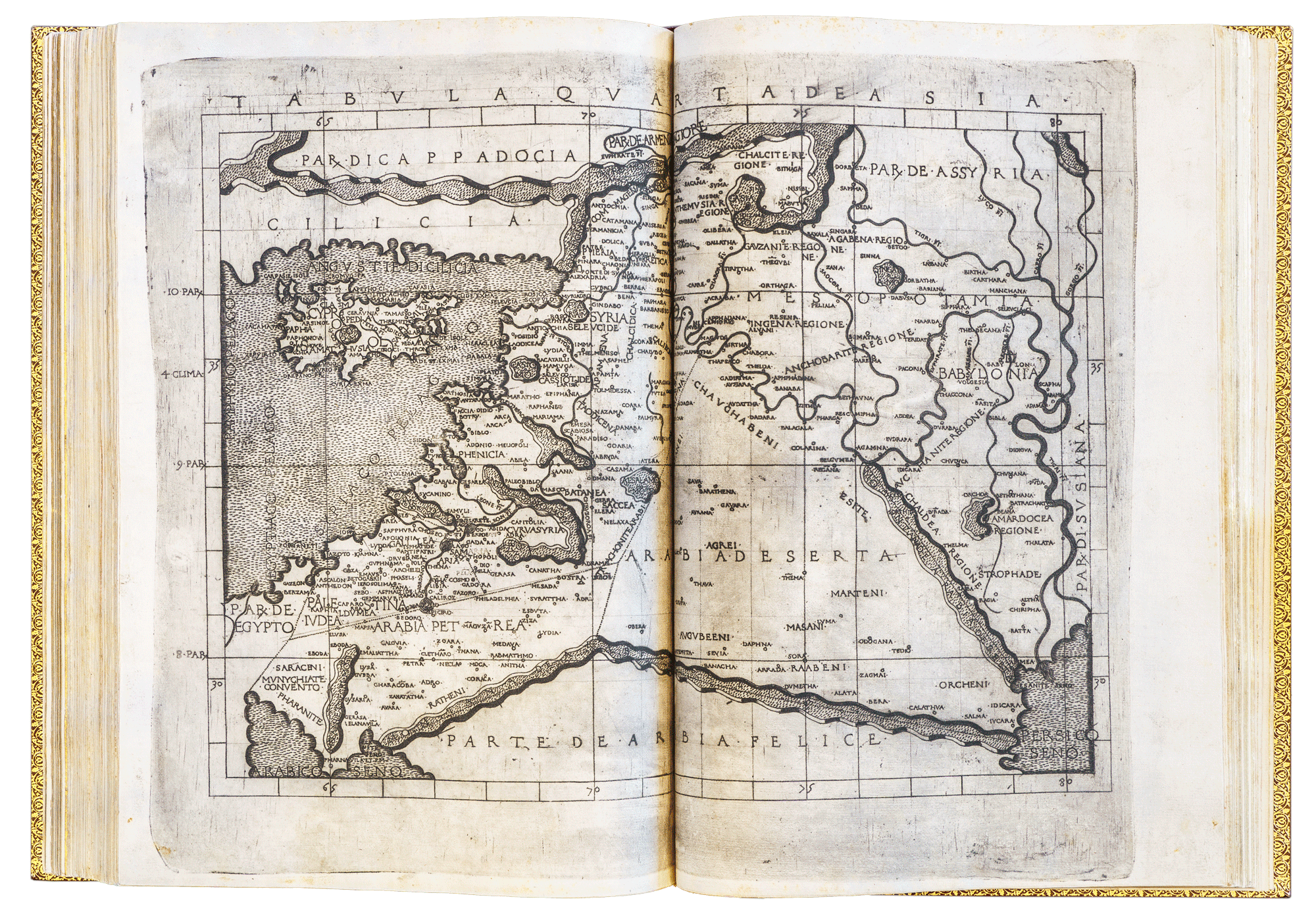
The oldest book in the Society’s Library is Ptolemy's Geographia di Francesco Berlinghieri, a folio volume published in Florence, Italy, by Nicolo Todescho Berlinghieri, ca 1480. This volume contains the calculations and art works of Claudius Ptolemy, 100 – c. 170 AD with 31 maps engraved on copper and is considered a monument of typography and the engraver's art.
This volume was printed using metal plates, which was at that time a pioneering work started in Italy, about 30 years after moveable typesetting was introduced by Johannes Gutenberg. The atlas has a 19th century gruel binding. This is possibly the oldest atlas held in Australia and the southern hemisphere. In the York Gate catalogue of 1886, the Ptolemy atlas of 1482 is described as dated 1480, catalogue no 1102.
Ptolemy lived in or around the city of Alexandria, in the Roman province of Egypt under Roman rule. He is known as the father of geography for his work on mapping the globe. Ptolemy was one of the great philosophers of the ancient world, who is regarded as the ‘father’ of geography and established a scientific and systematic basis for cartography, such as placing north at the top of the map. He completely missed the inverted triangular shape of India, and made Sri Lanka (which he called Taprobana) a vast island, nearly as big as France and Spain together. The Indian Ocean is displayed as a land locked ocean. These errors show how cartography, recording exploration, was still in its infancy. The New World was not depicted in the Ptolemaic Charts until 1507.
This folio volume with 31 maps engraved on copper and is considered a monument of typography and the engraver's art. This edition is the first to contains the 27 high quality modern world maps, updated from the ancient maps, and, in addition, four new modern maps of Gallia Novella (France) Hispania Novella (Spain), Novella Italia (Italy) and Palestrina Moderna (Palestine). Ptolemy’s maps are of a rectangular conception, with meridians and parallels intersecting at right angles. The book’s significance is also due to its place in the history of geography, atlases and the concept of Terra Australis.
Nicolo Francesco Berlinghieri (1440-1501) was an Italian humanist, scholar and poet who contributed to the Renaissance by promoting the value of classical Greek learning and was one of the first to print a text based on Ptolemy's Geographia.. Berlinghieri's book is a paraphrase in Italian verse of Ptolemy's 2nd century Geographia (according to the British Museum, the maps were probably founded upon those ancient maps in the Ptolemy printed by Buckink at Rome in 1478). Ptolemy developed the hypothesis, that held sway for more than one thousand years, that there was a huge continent in the southern hemisphere to balance the weight of the known land in the northern hemisphere. This hypothetical land was called Terra Australis nondum cognita or Terra Australis incognita.
This is the oldest book from the York Gate Library (and the RGSSA Library). Berlinghieri's volume was published in Florence in 1480, ten years before Christopher Columbus sailed from Spain to encounter the Americas. Columbus possibly knew of this folio as he sailed west looking for the East Indies in 1492.
The map of the world showing 'Terra incognita' in the south is one of the earliest maps to be printed from a metal engraving. The book is of international significance as one of the incunabula, books that were printed using metal type up to the year 1501, the birth period of printing in Europe. The Berlinghieri is a rare example of books from Europe – the place of origin – to Australia and it is one of the estimated 2,000 incunabula or less that are held in southern hemisphere collections.[1]
A major factor in the advancement of cartography was the rediscovery of Ptolemy’s work in 1400, having been stored in the Ottoman Empire since the destruction of the library at Alexandria in 642., and its general distribution throughout Europe during the 15th and 16th centuries’.[2] There is a certain irony that the invention of movable-type printing aided this distribution, as exemplified in Berlinghieri’s book, which soon followed publication of the first printed edition of Ptolemy’s work (1475).
[1] Incunabula is the plural of the Latin word for a cradle, incunabulum, and meaning ‘birth period’ or ‘beginning’. The British Library's Incunabula Short Title Catalogue currently records over 29,000 titles. There has been very little movement of incunabula since 1500 except to the US and Japan. Only around two per cent of them are held in collections in the southern hemisphere (the total number is estimated at less than 2,000). Wikipedia, Incunabulum National Diet Library, Japan, What are Incunabula?
[2] M Pearson, Great Southern Land, p 8.
Ptolemy was a skilled mathematician and astronomer and applied these skills to map making. He based the projections of the world on the world’s circumference being18,000 miles (28,800 kilometres) and developed a grid system based of latitude and longitude devised by Marinus of Tyre. Within this framework Ptolemy was able to establish the coordinates and in his major work Geographica he listed over 8,000 places and their respective coordinates. These were given in degrees, minutes and seconds, the system still used today.
Acquired with the York Gate Library in 1905 Catalogue No. 910 B515 d. Located in SLSA's Rare Book Room.
© The Royal Geographical Society of South Australia